Trailhead
A leisurely guide to the
Rogue River Valley's finest hiking trails!
Picnic
Basket
Rogue River
Trail reveals relaxing and romantic
locations for sharing a sumptuous afternoon repast with a friend. Fishin'
Hole
Where and how to catch
the big ones ~ the Steelhead are running NOW (my nephew caught a 32 incher
the other day, but he's from Texas...)
Nature
Lodge
What kind of mushroom
is that?!? Mmmm, matsutake season is here! Besides learning
to distinguish the gourmet marvels from the toadtools, we can also help identify
various other things—from birds to
butterflys—from
pond turtles to wildflowers!
The Map
Room
Yes, you can get there
from here, weather permitting...
Treehouse
Fun stuff you can do at
home (or at least in your own backyard...) Fireside
Tales
Poems, prayers & platitudes, plus a few outright
prevarications, and a little bit of history to boot—as told by
some of our greatest regional storytellers, past & present,
including the Rogue River Trail's own Hathaway Jones! Stone
Knives
& Bear Skins
Appropriate technology
& top-notch outdoor woodsman & survival skills make ' roughing it' easy!
Paydirt!
Where to go
if you're looking for the big nuggets. Trevillian's
Gold
Gold
panning is fine, as far as it goes, but Southern Oregon abounds in
lost treasures as well! Buck Trevillian spent most of his
life looking for one of them, but he never found it. Will
you? |
 Greetings!
John and Linda here, with a friendly reminder that Southern Oregon
is the most beautiful place in the World — and, in case you haven't
yet noticed, it's almost SPRING again! That's right; hibernation is going
out of style. It's time to get out of the cave and start planning this year's
adventures!
Greetings!
John and Linda here, with a friendly reminder that Southern Oregon
is the most beautiful place in the World — and, in case you haven't
yet noticed, it's almost SPRING again! That's right; hibernation is going
out of style. It's time to get out of the cave and start planning this year's
adventures!
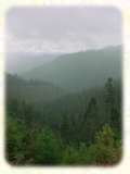 Spalding
Pond.
Once part of an extended logging operation in the mountains overlooking Briggs Valley, Spalding Pond and its surrounding
terrain has been gentrified
in recent years—with everything from parklike landscaping to a
handicapped accessible fishing dock (and yes, the pond is kept
well-stocked with trout!) The easiest access is to head
out towards Cave Junction (or towards Grants Pass if you're coming
from Cave Junction...) then turn off on the Briggs Valley Road near the
top of Hayes Hill. From this direction the signs should be enough to
guide you to the pond, only a few short miles from the Redwood Highway
turnoff. My favorite approach, however, is from the other side—coming up either from Taylor Creek or Shan
Creek—but be
forwarned, these routes can be a little bit rough—one of the prices we
have to pay for such spectacular views! READ MORE>>
maybe next week?
Spalding
Pond.
Once part of an extended logging operation in the mountains overlooking Briggs Valley, Spalding Pond and its surrounding
terrain has been gentrified
in recent years—with everything from parklike landscaping to a
handicapped accessible fishing dock (and yes, the pond is kept
well-stocked with trout!) The easiest access is to head
out towards Cave Junction (or towards Grants Pass if you're coming
from Cave Junction...) then turn off on the Briggs Valley Road near the
top of Hayes Hill. From this direction the signs should be enough to
guide you to the pond, only a few short miles from the Redwood Highway
turnoff. My favorite approach, however, is from the other side—coming up either from Taylor Creek or Shan
Creek—but be
forwarned, these routes can be a little bit rough—one of the prices we
have to pay for such spectacular views! READ MORE>>
maybe next week?